FTA Pilot 2016
DART Red Line and Blue Line TOD Planning
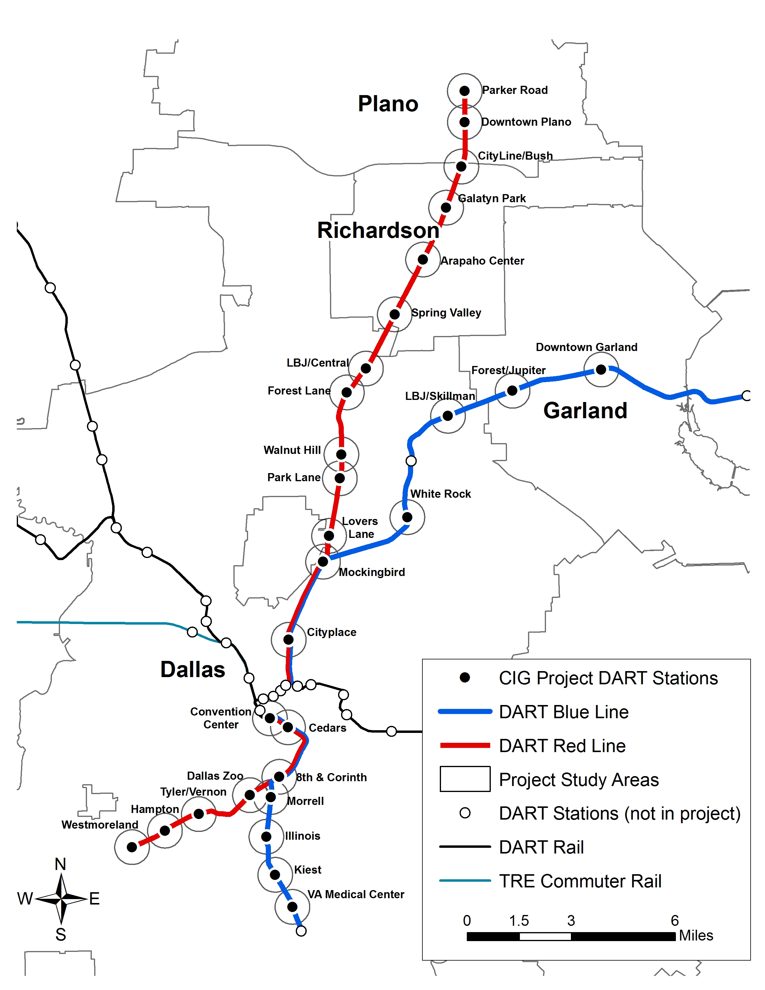
The Federal Transit Administration awarded NCTCOG a $1.4 million planning grant in 2016 to help the region enhance accessibility and development around 28 Dallas Area Rapid Transit stations along the system’s Blue and Red lines through the FTA TOD Planning Pilot Grant program. NCTCOG coordinated with DART and the cities of Dallas, Garland, Plano and Richardson to develop this corridor study. The TOD Pilot program objectives include:
- Address substantial barriers to TOD in the corridor to increase rail ridership
- Identify infrastructure needs to increase pedestrian and bicycle connectivity to rail stations
- Further enable dense mixed-use development and advance economic development of the station areas
The DART Red & Blue Lines Corridor TOD Study final report details overall summary and implementation recommendations for the corridor. The study included three major tasks prior to the final report: a first/last mile study, a parking study, and a survey.
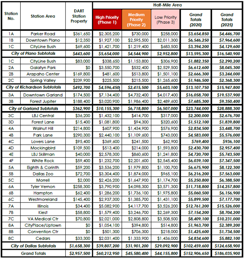
This assessment of streets, sidewalks, and other routes connecting the 28 DART rail stations examined infrastructure that will enhance first/last mile accessibility for pedestrians. The study included detailed evaluations of pedestrian infrastructure needs for corridors within a one-half mile radius of the DART facilities, wherein improvements were identified and ranked as High, Medium, and Low, based on the potential benefit to improve active user access to and from the stations. Estimated construction costs, primarily for new sidewalks and pedestrian safety measures such as crosswalks, signals and phasing for implementation, were developed for each station area. The resulting project deliverables and final reports were provided to DART and each city to be referenced during future project development, helping to improve access and connectivity for residents and workers with the key goal to increase transit ridership.
The Opinions of Probable Construction Costs for all stations are identified in the following table.
Click on the image for an enlarged view of the costs.
DART - NCTCOG Final Report [PDF, 52 MB]
- Appendix A Field Work Dates
- Appendix B Part 1 Data Collection Maps & Forms [PDF, 23 MB]
- Appendix B Part 2 Field Data Checklist - Stations [PDF, 48 MB]
- Appendix B Part 3 Field Data Checklist - Stations (Cont.) [PDF, 47 MB]
- Appendix B Part 4 Field Data Checklist - Stations (Cont.) [PDF, 59 MB]
- Appendix C Crosswalk Improvement Evaluation Details
- Appendix D Crosswalk Improvement Selection Tables
- Appendix E Half-Mile Area Improvement Prioritization - Initial Trial Methodology Details
- Appendix F Half-Mile Area Improvement Prioritization - Final Methodology Details [PDF, 1.2 MB]
- Appendix G Cost Estimating Details
- Appendix H Estimated Quantities & Opinions of Probable Construction Cost - Station Property Improvements [PDF, 1.5 MB]
- Appendix I Half-Mile Area Recommendation Details & Detailed Improvement Mapping [PDF, 94 MB]
- Appendix J Half-Mile Improvement Matrices [PDF, 8.3 MB]
- Appendix K Estimated Quantities & Opinions of Probable Construction Cost - Half-Mile Improvements [PDF, 3.8 MB]
Dallas Final Report [PDF 32 MB]
- Appendix A Field Work Dates
- Appendix B Data Collection Maps & Forms [PDF, 72 MB]
- Appendix C Crosswalk Improvement Evaluation Details
- Appendix D Crosswalk Improvement Selection Tables
- Appendix E Half-Mile Area Improvement Prioritization - Initial Trial Methodology Details
- Appendix F Half-Mile Area Improvement Prioritization - Final Methodology Details
- Appendix G Cost Estimating Details
- Appendix H Estimated Quantities & Opinions of Probable Construction Cost - Station Property Improvements
- Appendix I Half-Mile Area Recommendation Details & Detailed Improvement Mapping [PDF, 12 MB]
- Appendix J Half-Mile Improvement Matrices [PDF, 7 MB]
- Appendix K Estimated Quantities & Opinions of Probable Construction Cost - Half-Mile Improvements [PDF, 2 MB]
Garland Final Report [PDF, 24.5 MB]
Plano Final Report [PDF, 33 MB]
Richardson Final Report [PDF, 39 MB]
Data collection of private automobile parking utilization, policy, and management practices at existing transit-oriented developments along the DART Red Line and Blue Line. The report provides recommendations supporting transit-appropriate parking ratios and other parking management best practices for TODs.
TOD Parking Study
Interactive Best Practices Toolbox Website
- Appendix A - Site Summaries
- Appendix B - Data Results Comparative Matrix
- Appendix C - Questionnaire Form and Results
- Appendix D - Description of Shared Parking Model
- Appendix E - Recommendations for Parking Data Collection
The survey includes residents, businesses, and their employees near the 28 DART stations and focuses on their perceptions and behavior related to transit and related urban development. The findings provide a sense of trends and patterns in the demographics, stated preferences, and behaviors of those living and working near the rail stations, better informing the opportunities for local government policies and programs supporting TOD.
Report Document
- Appendix A - Responses to Resident Survey
- Appendix B - Responses to Employer Survey
- Appendix C - Responses to Employee Survey
- Appendix D - Survey Methodology
- Appendix E - Survey Materials
Staff contact: Travis Liska