Sustainable Zoning and Development Code
As growth continues in the Dallas-Fort Worth region, the land use and street design policies will need to evolve to ensure sustainable transportation outcomes. Continuing to add roads and highway lanes can result in the unintended consequence of inducing more traffic congestion and its associated safety and environmental challenges. Integrating transportation planning with land use planning and design can facilitate multimodal travel, which can reduce traffic congestion by providing viable alternatives to the automobile.
Sustainable zoning and design practices integrate building form and public street design considerations with transportation options. These practices can be used to enable safe, convenient, and comfortable environments for pedestrians, bicyclists, and transit users.
Most zoning practices in North Texas focus on separating land uses. This often spreads destinations further apart, requiring longer travel distances. Many zoning and development codes also lack design guides or requirements for all travel modes and transportation contexts. The current default in many codes is to only facilitate design for cars.
Sustainable zoning codes can remove barriers by including a mix of uses and housing types. This increases access between land uses and allows shorter travel distances. Sustainable zoning also has a greater focus on the design and form of buildings and streets to accommodate facilities for pedestrians, bicyclists, and transit users, as well as cars.
Design guides and requirements used in zoning for building placement, orientation, and interface with the streetscape can support increased walkability and other modes. Often these will have site design specifications for things like the façade, entrance placement, and building setback. Recommended design for transit-oriented development (TOD) is a good example of walkable and pedestrian oriented design. See NCTCOG’s TOD Inventory method document for an overview of good site design criteria and local examples.
NCTCOG developed a Sustainable Zoning Guidebook as a resource for North Texas with information on locally-adopted zoning approaches supporting walkable, mixed-use, and transit-oriented developments. Using a review of codes from 36 North Texas cities, the guide provides a picture of regional sustainable zoning trends and options cities can review and possibly adopt in support of sustainable land use and transportation coordination.
Form-Based Codes
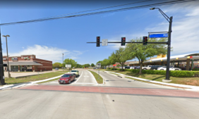
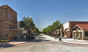
Form-Based Codes focus on regulating the design of buildings and properties rather than the type of land use. Form-based codes can help create pedestrian-friendly environments by highlighting the relationship among street context, streetscapes and building facades, form, and placement. In turn, this focus can encourage more sustainable travel patterns. To illustrate the form-based codes concept, take two examples of a two-lane road with land zoned for commercial uses. The one on the left is use-based zoning, while the one on the right is form-based. Which street looks more inviting to walk along?
 |
 |
| Used-based zoning | Form-based zoning |
| Photos courtesy of Google Earth | |
Several communities in North Texas are using variations of form-based code:
| City | Form-Based Code |
|---|---|
| Carrollton | Transit Center District Regulations |
| Dallas | Chapter 51A Article XIII: Form Districts |
| Duncanville | Downtown Duncanville District |
| Farmers Branch | Form-Based Code for Farmers Branch Station |
| Fort Worth | Near Southside Development District |
| Frisco | Form-Based Codes Manual |
| Keller | Old Town Keller Overlay District |
| McKinney | Town Center Zoning District |
| Mesquite | |
| North Richland Hills | Transit-Oriented Development District Code |
| Richardson | Main Street/Central Expressway FBC |
| Roanoke | Oak Street Regulating Plan |
The organizations linked below provide more information and examples of form-based codes:
- Form-Based Code Institute: https://formbasedcodes.org
- SmartCode Manual: https://transect.org/codes.html
Pattern Zoning
Pattern Zoning is a zoning tool that can be used to accelerate the permitting process and reduce costs in development projects. “Pattern buildings”, pre-approved building designs of different sizes and densities, are provided for developers to implement quickly and easily through the zoning approval process. This strategy can reduce costs for infill development and create higher-quality housing stock.
The City of Bryan, TX implemented pattern zoning in the Midtown Area, as a part of the Midtown Area Plan. To read the guidebook and learn more about Pattern Zoning, visit https://www.bryantx.gov/midtownpark/
The City of South Bend, IN implemented pattern zoning into their city with the creation of their “South Bend Neighborhood Infill”. The plan takes advantage of South Bend’s many vacant lots by providing pre-approved building plans, as well as building variations to increase value and reduce construction costs with multiple façade options. To learn more about South Bend’s Pre-Approved Building Plan Sets, visit https://southbendin.gov/bsb/preapprovedplans/
This section focuses on street connectivity. For Complete Streets and Context Sensitive Design, click here.
Incorporating sustainable street design as part of a unified zoning and development code can also help ensure safe and comfortable built environments for bicyclists and pedestrians.
Historically, roadway system design trends shifted to a hierarchical-style design in the 1950s, encouraging designs that filtered traffic from smaller roads into a few higher-capacity main roads. These hierarchical designs are codified in municipal codes regulating street design and subdivision development throughout North Texas. While hierarchical designs can help reduce through traffic in some areas, some unintended consequences include:
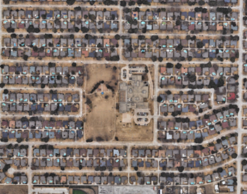
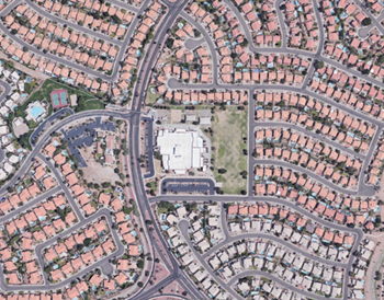
- Creating large "superblocks" which makes walking or biking to local destinations circuitous and provides few opportunities for safe roadway crossings.
- Higher rates of traffic and pedestrian fatalities.1
- Higher travel speeds, which result in longer distances required to stop.1
- Longer travel distances, which is linked to worsened air quality and associated with a reduction in direct routes.3
 |
 |
| Example of good connectivity to a school. | Example of poor connectivity to a school. |
| Photos courtesy of Google Earth | |
What are connected street grids? What are their benefits?
Connected street grids are road networks with a non-hierarchical layout, short blocks, and well-connected intersections. Connected street grids provide:
- More direct routes to destinations for all road users, which encourages bicycle and pedestrian travel modes. For example, volumes of pedestrian trips can be three times greater in urban sites with short street blocks and continuous sidewalks than sites with large blocks and discontinuous sidewalks.2
- More crossing opportunities for pedestrians at safe and convenient crossing locations.
- Increased intersection density is associated with reduction in vehicle miles traveled after controlling for other socio-economic and environmental factors.3
For a connected street grid primer, see: Street Networks 101 | CNU
In January 2022, NCTCOG hosted a Connected Street Network and Subdivision Design" webinar discussing the benefits of more connected street grids for walkability and designing networks to enable students to safely walk or bike to school. To see a recording of the webinar as well as the presentations slides, please see the School Site Planning and Access page.
Additional Resources and Tools
USDOT: Promoting Connectivity Resources
- Outlines benefits of street connectivity, health benefits, and examples of connectivity analysis.
KYTC Street Connectivity Model Ordinance
- Example ordinance created by the Kentucy Transportation Cabinet for local governments to adopt internal and external connectivity requirements for subdivisions.
H-GAC Connectivity Improvement Tools and Recommendations
- Document reviews Texas regulations and presents strategies to improve network connectivity in MTPs and better subdivision design.
Examples of Street Grid Implementation
City of Fort Worth Connectivity Requirements (Article VI)
- Fort Worth has adopted subdivision design standards that require new street networks to have a connectivity index of 1.4 or greater, calculated by the number of links (streets) by nodes (intersections, cul-de-sacs, etc.).
Bastrop Building Blocks (B3) Code
- Bastrop, TX, a suburb of Austin, completed a fiscal sustainability analysis and found that the only fiscally sustainable part of the city was their downtown area, with square blocks. Their new code models all new development from this form and created "place type" requirements for developers to follow.
