2005 Digital Orthophotography
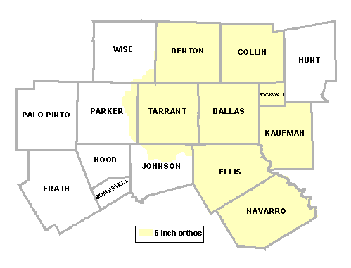
In 2005, the North Central Texas Council of Governments facilitated the purchase of 6-inch digital orthophotography (orthos) for the following eight counties in North Central Texas: Collin, Dallas, Denton, Ellis, Kaufman, Navarro, Rockwall and Tarrant.
The contractor for this project was Bohannan Huston. The orthos were collected from January to March of 2005 and are available for purchase via the DFWMaps Marketplace according to the following price schedule.
Georeferenced TIFF images are sold in 3,000' x 2,000' tiles, or 0.215 square miles. Sample images and a shapefile of the tile structure may be downloaded below:
6-Inch Resolution Color Ortho Sample [TIFF format with world file; 50 MB]
1-Foot Resolution Color Ortho Sample [TIFF format with world file; 14 MB]
2-Foot Resolution Color Ortho Sample [TIFF format with world file; 3.7 MB]
4-Foot Resolution Color Ortho Sample [TIFF format with world file]
8-Foot Resolution Color Ortho Sample [TIFF format with world file]
Specifications
Color aerial photography were acquired using a Z/I Digital Mapping Camera (Z/I DMC) which has been proven accurate for photogrammetry mapping by the USGS digital sensor evaluation program at Stennis, Mississippi. The flight design achieved a nominal ground-pixel resolution sufficient for developing 6" pixel orthophotography without oversampling. It was also designed with sufficient forward overlap and strip side laps to ensure total project area coverage.
Aerotriangulation is performed using industry-accepted procedures on an approved softcopy workstation or analytical stereoplotter to support the horizontal accuracy requirements of the digital orthophotography. RMS of known ground points does not exceed 1 foot in x, y, or z.
| Altitude of Capture | 4,500' above mean terrain |
| Focal Length | 120 mm (4.72") |
| Imagery Scale | 1"=950' (Photo scale 1:11,400) |
| Capture Period | January-March 2005 |
| Conditions | Leaf off, cloud free, optimum sun angle |
| Forward Overlap | 60% |
| Sidelap | 25% |
| Coordinate System | Texas State Plane, North Central Zone |
| Horizontal Datum | NAD 83 |
| Units | US Survey Feet |
| Format | TIFF or MrSID (1 MrSID tile = 120 TIFF tiles) |
View the Metadata for more information on the 2005 Orthophotography Project.
Note: Participants who received MrSID files may need to download an extension to view Generation 3 MrSID files in ArcView 3.x or AutoCAD. Click here to download the extension.
For questions about 2005 digital aerial photography, send us an email.