Floodplain Management
 Relevant Committees
The Environment & Development Department maintains a variety of programs to reduce flood damages in the North Texas region.
Community Rating System (CRS) Users Group
The Community Rating System (CRS) is a voluntary incentive program that recognizes and encourages community floodplain management practices that exceed the minimum requirements of the National Flood Insurance Program (NFIP). Classes are rated from 9 to 1.
Many CRS communities across the U.S. have formed CRS Users Groups representing municipal, county, regional, and state networks that collaborate to meet local floodplain mitigation goals, and support one another in qualifying for CRS credit. More information about the North Central Texas Users Group may be found at www.nctcog.org/envir/watershed-management/crs-user-group.
OneRain - Regional Flood Warning Software Program
The Regional Flood Warning Software Program provides each participating entity with enterprise-level hydrologic and flood warning software to help support critical missions. The program will leverage existing gauging networks in the region to provide a centralized-view to alarm, visualize, and disseminate information of the real-time conditions impacting each participating agency.
NCTCOG has entered into an agreement with OneRain to provide products and/or services to participating TxShare entities. Participating entities must first complete an ILA with Texas TxShare, a program of NCTCOG, to access these products/services.
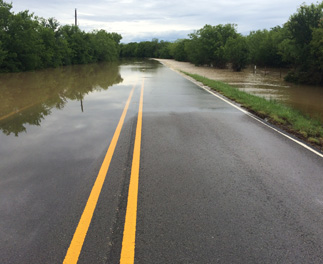
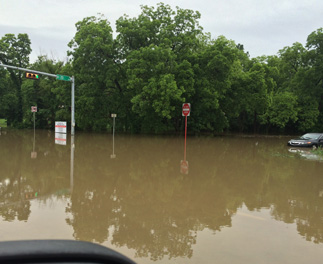
Regional Flood Photo Database
NCTCOG has collected photos of flooding events that have occurred in North Texas in 2015 and 2018. Photos may be used in presentations and reports with full credit to further the important discussion of floodplain management in North Texas.
View the 2018 Flood Photo Library View the 2015 Flood Photo Library


CRS Users Group/Elected Officials Floodplain Seminar
Tuesday, October 25, 2022
View Seminar Agenda
View Presentations
CRS Users Group/Elected Officials Floodplain Seminar
Thursday, July 29, 2021
View Seminar Agenda
View Presentations
CRS Users Group/Elected Officials Floodplain Seminar
Thursday, July 30, 2020
View Seminar Agenda
View Presentations
CRS Users Group Meeting/Elected Officials Floodplain Seminar & CHARM Policy Workshop
Thursday, July 18, 2019
View Seminar Agenda
View Presentations
Elected Officials Seminar & CRS Users Group Meeting
Wednesday, July 18, 2018
View Seminar Agenda
View Presentations
Elected Officials Seminar & CRS Users Group Meeting
Wednesday, August 23, 2017
View Seminar Agenda
View Presentations
Elected Officials Seminar & CRS Users Group Meeting
Wednesday, August 31, 2016
View Seminar Agenda
View Presentations
Elected Officials Seminar & CRS Users Group Meeting
Thursday, August 6, 2015
View Seminar Agenda
View Presentations
Floodplain Management Seminar for Policy Makers
Friday, September 26, 2014
View Seminar Agenda
View Presentations
The North Central Texas Council of Governments (NCTCOG) has compiled the following report on the May-June 2015 floods as not only an informational piece but as part of an ongoing effort to lessen impacts of floods on our region.
The spring 2015 floods in Texas are often referred to as the Memorial Day Floods. However, weather events in late winter and early spring of 2015 saturated the soil and set the stage for record flooding when several weather systems followed in May and June, delivering a devastating blow to much of Texas. Area lakes and the Trinity River system were overwhelmed with excess water, causing record and near record flooding. These events prompted the President of the United States to issue a major disaster declaration May 29. The Federal Emergency Management Agency (FEMA) later identified an incident period of May 4, 2015, to June 22, 2015.
View the Flood Report View the Flood Photo Library